Main workflow description
On-site survey: In the cultural and museum industry, each field has a different on-site environment. For example: in the field of ancient architecture, the layout and beam structure of buildings in different ages and regions are different. Under the strict hierarchical system in ancient times, there are also huge differences between official buildings and ordinary dwellings. Similarly, the layout of furnishings in each building is different. Especially in the movable collection of cultural relics, there are many types, materials, and shapes of various cultural relics. Therefore, site survey is the primary task to ensure the selection of subsequent project equipment, project construction period calculation, and safety protection plan setting.
Plan formulation: Fully communicate with data users on the basis of on-site survey, discuss and determine the completeness, fineness, and future use directions of the data. On the basis of full investigation and detailed communication in the early stage, the on-site work plan arrangement, scanning period, data submission standards, etc. are determined. Only a meticulous scanning plan can save costs to the greatest extent and ensure the validity of later data.
Data processing: The post-use of data in the cultural and cultural industry mainly focuses on two aspects. One is to provide accurate basic data for the protection of ancient buildings, ancient ruins, and cultural relics in collections. The data can be used to complete the project declaration, repair plan design, current data storage of ancient buildings, ancient ruins, and ancient tombs. The second is to use scanned data to increase the depth and breadth of public propaganda of cultural heritage such as cultural relics and ancient buildings in the collection through digital communication methods.
Archaeological excavation site
Application background: At present, a large amount of archaeological work is cooperating with the construction of urban infrastructure, and there are often time conflicts between the project construction period and the archaeological work. After the excavation is completed, due to the requirements of the archaeological report, the regulations stipulate that various drawings must be drawn, which is arduous and long.
Technical advantages: data is complete, comprehensive, visible and can be stored permanently.
Data application: archiving, research, publicity and display.
Collection of cultural relics
Application background: At present, there are tens of millions of cultural relics in domestic museums. Due to the fragility of cultural relics and the relatively high requirements for the collection environment such as temperature and humidity, a large number of precious cultural relics can only be stored in underground warehouses. Exhibitions and the transmission of cultural information have brought many obstacles. The country is already carrying out the digitization of cultural relics in the collection, but if only ordinary forms of cultural relics statistics and data storage are used, it is far from reflecting the precise information of the specific form and size of the cultural relics. Once the cultural relics are damaged, there is no accurate data to restore. , Copy and reproduce.
Technical advantages: high precision, three-dimensional data storage.
Data application: archiving, research, protection plan formulation, copying, publicity and display to the public.
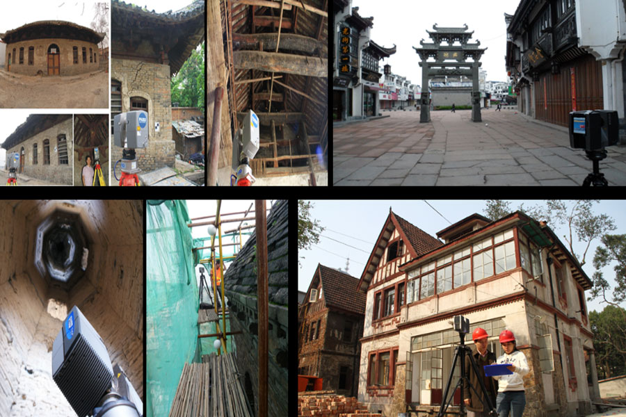
Ancient architecture field
Application background: Ancient architecture is the carrier of Chinese traditional culture and construction technology. Existing ancient buildings such as building materials, history, natural disasters, etc. are becoming more and more precious. In the past, due to technical reasons, ancient buildings did not have or lacked complete current drawings.
Technical background: Three-dimensional scanning technology collects the spatial structure information and construction information of ancient buildings into the computer with a data collection volume of nearly one million points per second. In this way, an accurate and complete current drawing of the ancient building can be drawn.
Technical advantages: data is complete, comprehensive, visible and can be stored permanently.
Data application: Four-owned archives, research, protection and repair plan design, publicity and display.
Q&A of the common problems of 3D scanning in the cultural industry
- What is the output format of point cloud data?
1.1 Large scene equipment: The commonly used point cloud formats are: PTS, XYZ, TXT, etc. Although equipment from different manufacturers will produce data in different formats, with the continuous development of industry software in recent years, more and more software can be accepted More data formats. You can also easily convert the required format through third-party software.
1.2. High-precision equipment: Although the technical principles of the equipment of various manufacturers are different, they can basically generate triangle patch models in common formats such as STL and OBJ. - Whether the scanned data has texture information:
2.1 Large-scene scanning equipment: The equipment has its own color collection device, which can collect texture data at the same station while collecting data from a single station. Color collection will increase working time and data volume. In engineering practice, generally only point cloud data containing reflectivity is used.
2.2 High-precision scanning equipment: In recent years, high-precision scanning equipment is also equipped with a color collection device, which has the function of texture data collection while performing three-dimensional data collection. However, due to light, equipment performance and other reasons, the color reproduction requirements of the cultural and museum industry are often not met. - Project construction period: In the early stage of the project, the data collection and data processing time will be determined according to the on-site survey and the application direction of the later data. In the later stage, the work will be completed and the data will be delivered according to the time specified in the contract.
- Scanning job site requirements: Three-dimensional scanning cannot collect data on objects with refraction and reflection such as glass, water, and colored glaze. A safe temporary room is needed for charging and the placement of equipment and auxiliary equipment.
- How to apply point cloud data later: Point cloud data is raw data, and can be imported into different professional software for processing according to different application requirements in the later stage. Such as 3DMAX, VR software, CAD or professional cultural and expo system data management system.
- How to display point cloud data: The amount of point cloud data is large and must be displayed using software that supports point cloud. The software is divided into processing software and industry software. The processing software is used for preprocessing the original data such as splicing, noise reduction, and format conversion. Professional software is to form the model format, modification, etc. required by the industry according to different needs. It is also possible to use third-party platforms to browse and measure point clouds.
- Can the point cloud be directly used for display? The original point cloud data can be directly used for display, but because the perspective of the point cloud does not conform to human visual habits and the large amount of data is inconvenient to operate, in most cases, it will be used in reverse for different formats of 3D models according to industry needs.
- Point cloud data coordinate situation: In most cases, the point cloud data uses the self-built coordinate system to work, and the point cloud database of relative coordinates is obtained. In engineering, absolute coordinate data can also be obtained with the cooperation of total station or RTK.
- Can the accuracy be reduced and the data collection cycle can be shortened if high accuracy is not required in the project? The scanning accuracy of current scanning equipment is definite, and the data accuracy cannot be reduced.
- What is the cycle of a complete scan project? A complete scanning project cycle includes data collection, data preprocessing, data processing, and post-extended applications.
- What is the data collection cycle related to: Data collection is related to the complexity of the site structure and object. The more complex the structure or object, the more station or scanning time is required to ensure data integrity. The collection cycle is also related to the on-site environment: the data collection time will be prolonged under dangerous, high-altitude, or frequent activities of personnel and equipment.
- What is the data preprocessing cycle related to: Data preprocessing is related to factors such as the amount of data, whether colors are needed, and invalid data.
- What is the data processing cycle related to: Data processing is related to industry applications, and different industries or applications have different requirements for data precision. The higher the precision or the more complex the site, the longer the post-data processing cycle.
- Can point cloud data directly generate a model for exhibition display: No, if it needs to be used in exhibition display later, it must be modeled, optimized, mapped in the software according to the specific requirements of different applications such as VR, 3D animation, etc. Baking or rendering work.